Description
PolygonsFromCSV plugin allows user to create polygons based on polygon name (ident) and vertices (nodes) coordinates stored in CSV (comma-separated values) file.
GitHub repository: PolygonsFromCSV
Usage
To create polygons from CSV file just:
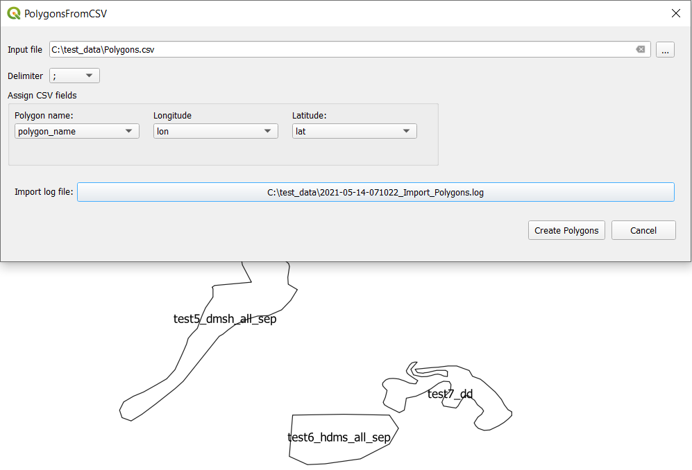
- Open PolygonsFromCSV plugin.
- Click button
 to select an input CSV file.
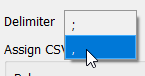
 - The plugin will automatically detect CSV fields based on a specified delimiter by drop down list
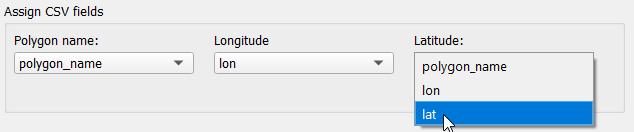
You can change the delimiter to the one that corresponds to the actual delimiter in the input CSV file. - Use drop down lists to assign CSV fields to variables that will construct polygons: Polygon name, Longitude, Latitude.
- Press button
 to create polygons.
 - Memory layer with polygons will be added to the map canvas.
Notice that the name of the memory layer is created automatically according to pattern:
[year]_[month]_[day_of_month]_[hour][minute][microsecond as a decimal number] example: 2021_03_15_0741401160 - Click button with path to import log file to see the log.

Supported coordinate formats
Following coordinate formats are supported:
- Decimal Degrees (DD), example: 55.50
- Degrees, Minutes, Seconds (DMS), with a hemisphere (direction) prefix or suffix separated, example: 55 30 00.00N, 55 30 00.00 N, N55 30 00.00, N 55 30 00.00
- Degrees, Minutes, Seconds (DMS), with a hemisphere (direction) prefix or suffix compacted, example: 553000.00N, 553000.00N
Input data structure
- Input data is in CSV file format
- Delimiters: comma or semicolon
- At least three CSV fields required for: polygon name (ident), longitude, latitude
- Vertices that form polygon should have the same polygon name (ident) value
Examples:
- One polygon - first and last vertex (node) are the same, coordinates in DD format:
polygon_name;lon;lat
TEST1;17.71691118216151395;54.51085314802783444
TEST1;18.04872820768914465;54.41201403404087955
TEST1;17.90046953670871233;54.24963548963373938
TEST1;17.71691118216151395;54.51085314802783444
polygon_name;lon;lat
test_dmsh;015 52 33.965 E;55 19 26.678 N
test_dmsh;015 57 24.954 E;55 19 40.212 N
test_dmsh;015 59 40.298 E;55 16 51.032 N
test_dmsh;015 59 33.531 E;55 13 21.249 N
test_dmsh;015 57 18.187 E;55 12 00.043 N
test_dmsh;015 54 42.542 E;55 11 05.906 N
test_dmsh;015 52 33.965 E;55 19 26.678 N
test_dmsh_comp;0160814.604E;551651.032N
test_dmsh_comp;0162328.175E;551529.826N
test_dmsh_comp;0162254.339E;551200.043N
test_dmsh_comp;0162133.132E;551011.768N
test_dmsh_comp;0161749.815E;550823.493N
test_dmsh_comp;0160929.043E;551401.853N
test_dmsh_comp;0160814.604E;551651.032N
test_hdms;E015 52 47.500;N55 05 37.697
test_hdms;E016 00 20.901;N55 08 47.178
test_hdms;E016 02 36.245;N55 09 21.014
test_hdms;E016 05 05.123;N55 08 40.411
test_hdms;E016 07 40.768;N55 07 32.739
test_hdms;E016 10 02.879;N55 06 11.533
test_hdms;E016 12 24.990;N55 05 10.628
test_hdms;E016 14 26.800;N55 04 09.724
test_hdms;E016 15 20.937;N55 03 49.422
test_hdms;E016 15 48.006;N55 00 53.475
test_hdms;E016 14 20.032;N54 58 58.433
test_hdms;E016 11 10.551;N54 56 56.624
test_hdms;E016 08 41.673;N54 56 16.021
test_hdms;E016 05 45.726;N54 56 02.486
test_hdms;E016 03 23.615;N54 56 49.857
test_hdms;E016 00 27.668;N54 57 37.227
test_hdms;E015 57 38.489;N54 59 11.968
test_hdms;E015 55 50.214;N55 00 26.407
test_hdms;E015 55 43.447;N55 00 39.941
test_hdms;E015 52 47.500;N55 05 37.697
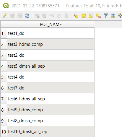
Output data structure
Polygons are stored in memory layer with one field: POLE_NAME, type sting, lenght 100.
Import log file
Import log file is created in the same directory as input csv file.
Following rule is apllied to create import log file name:
[year]-[month]-[day_of_month]-[hour][minute][second]_Import_[input CSV file name].log example: 2021-03-21-222206_Import_Polygons.log
Import log file contains following information:
- Input data file full path
- Polygon name (ident) and number of vertices if polygon is added to the ouptut layer
- In case there is not possible to create vertex or polygon from input data - one of the following reasons will be in file:
- There are not enough vertices to create polygon
- There is a missing field for data such as longitude and/or latitude
- Field is empty - contains only blank characters
- Coordinate is incorrect or in not supported format
Examples
- CSV data is correct - no 'missing' or empty fields, no incorrect or not supported coordinate formats
2021-03-21 15:56:00.934063 | INFO | Importing polygons from file C:\test_data\Polygons.csv started.
2021-03-21 15:56:00.951823 | INFO | Polygon added to output layer. Polygon test1_dd, vertices count 7.
2021-03-21 15:56:00.956806 | INFO | Polygon added to output layer. Polygon test2_dd, vertices count 7.
2021-03-21 15:56:00.962377 | INFO | Polygon added to output layer. Polygon test3_hdms_comp, vertices count 20.
2021-03-21 15:56:00.967361 | INFO | Polygon added to output layer. Polygon test4_dd, vertices count 20.
2021-03-21 15:56:00.973726 | INFO | Polygon added to output layer. Polygon test5_dmsh_all_sep, vertices count 51.
2021-03-21 15:56:00.979058 | INFO | Polygon added to output layer. Polygon test6_hdms_all_sep, vertices count 10.
2021-03-21 15:56:00.985042 | INFO | Polygon added to output layer. Polygon test7_dd, vertices count 109.
2021-03-21 15:56:00.990024 | INFO | Polygon added to output layer. Polygon test8_dmsh_comp, vertices count 9.
Input data:
CSV file header:
ident;latitude;longitude
Data file sample:
test11_dd;55.2808422982;15.9945272716
;55.2225693033;15.9926474976
test11_dd;55.2000120149;15.955052017
test11_dd;55.1849738227;15.9118172144
test11_dd;55.3240771008;15.8761015078
test21_dd;55.2808422982;16.1373900979
test21_dd;55.2582850098;16.3911595918
test21_dd;;
test21_dd;55.1699356304;16.3592034333
test21_dd;
test21_dd;55.2338479474;16.1580676122
test21_dd;55.2808422982;16.1373900979
Log:
2021-03-21 22:29:53.717796 | INFO | Polygon added to output layer. Polygon test8_dmsh_comp, vertices count 9.
2021-03-21 22:29:53.762172 | INFO | Polygon added to output layer. Polygon test9_hdms_comp, vertices count 1494.
2021-03-21 22:29:53.823338 | INFO | Polygon added to output layer. Polygon test10_dmsh_all_sep, vertices count 1332.
2021-03-21 22:29:53.829218 | ERROR | Empty field ident.  OrderedDict([('ident', ''), ('latitude', '55.2225693033'), ('longitude', '15.9926474976')])
2021-03-21 22:29:53.834656 | INFO | Polygon added to output layer. Polygon test11_dd, vertices count 6.
2021-03-21 22:29:53.839758 | ERROR | Empty field latitude. Empty field longitude.  OrderedDict([('ident', 'test21_dd'), ('latitude', ''), ('longitude', '')])
2021-03-21 22:29:53.845301 | ERROR | Empty field latitude. Missing field longitude.  OrderedDict([('ident', 'test21_dd'), ('latitude', ''), ('longitude', None)])
2021-03-21 22:29:53.850847 | INFO | Polygon added to output layer. Polygon test21_dd, vertices count 5.